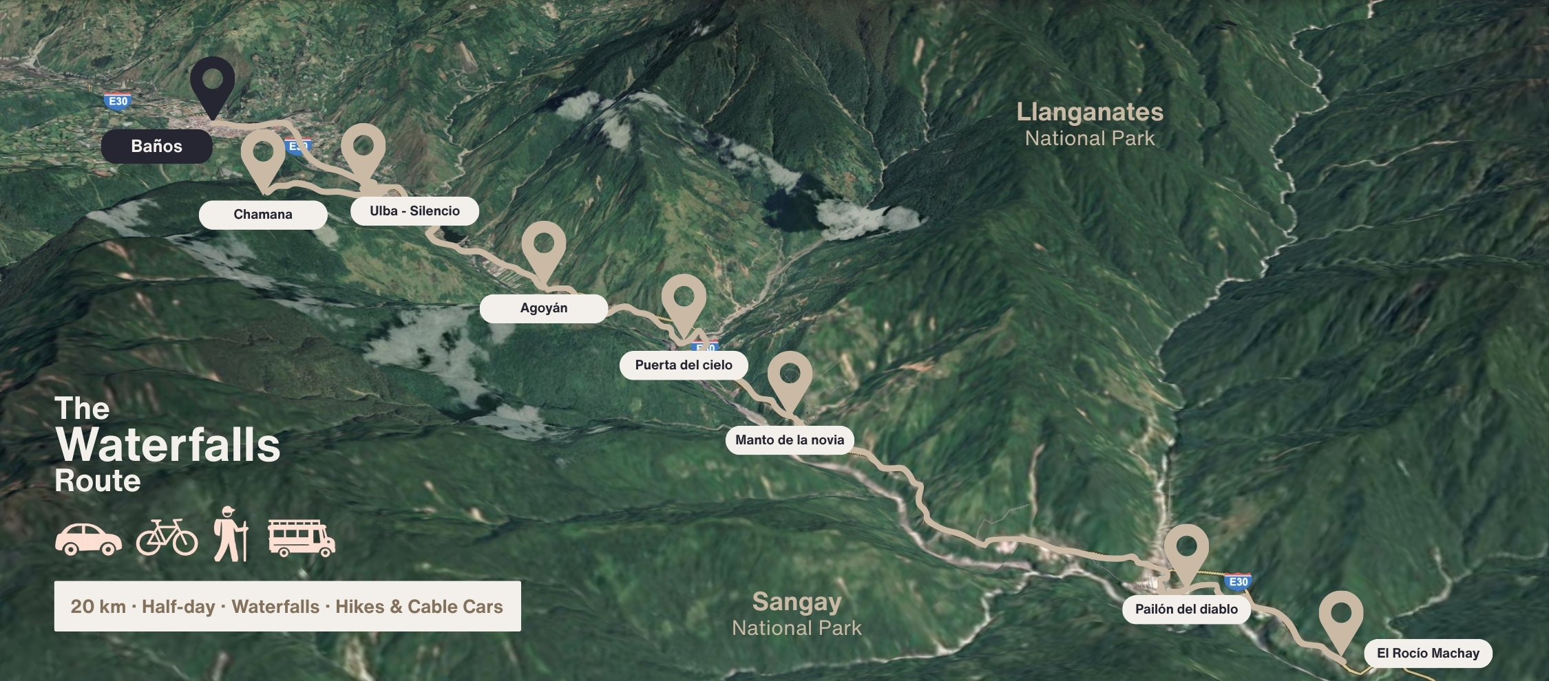
A scenic road carved by water and time—home to Baños’ most impressive waterfalls and easy to explore in one day.
The Waterfalls Route is a 20-kilometer stretch of road that connects Baños with the Amazon basin. It follows the Pastaza River through a narrow canyon, dropping from the Andes into the jungle.
On one side: Llanganates National Park. On the other: Sangay National Park. The route features at least eight named waterfalls, several cable cars (tarabitas), and viewpoints you can stop at by bike, taxi, or guided tour—all in one direction, all downhill.
Private Car: Offers maximum flexibility to visit waterfalls and other points of interest at your own pace. You'll enjoy greater comfort, weather protection, and ample space for equipment, food, and drinks, ideal for a personalized tour.
Bicycle: Provides an immersive experience, connecting you directly with nature and perfect for active travelers who want to stop easily anywhere. You'll feel the fresh air and have the freedom to truly soak in each scenic spot.
"Chivas" (Party Buses): While popular, they typically make very short stops at each point. This limits your ability to fully explore and enjoy each waterfall at your own pace, offering less freedom than a car or bike.
By Car: A round trip can take around 3-4 hours, allowing for stops at key waterfalls and attractions.
By Bicycle: Cycling the route (which is mostly downhill one-way) typically takes 4-5 hours. Many people then hire a truck to bring them and their bikes back to Baños.
Yes, but most travelers focus on 4–6 waterfalls that match their style and timing.
No. Most are accessible independently. Private tours are optional but recommended if you are short on time.
Yes, and it’s one of the most popular ways to explore it. The route is mostly downhill from Baños toward Río Verde, making it suitable for casual cyclists. Bikes can be rented in town, and trucks are available to transport you and your bike back.
Morning is best, ideally between 8:00 am and 1:00 pm. This timing offers better light for photos, fewer crowds, and more stable weather conditions.
This page works as a self-guided route. Below you’ll find each waterfall in order.
For every stop, you’ll get:
• A clear photo
• A short, practical description
• A direct link to its exact location
So you can navigate the route easily by bike or car.
Flowing from the same river as Chamana, El Silencio lives up to its name. Few travelers make it here, which makes the spot ideal for a quiet picnic or a refreshing dip in the water. Surrounded by greenery and away from the noise of the main route, it’s one of those rare places where you can pause and feel Baños at a slower rhythm.

Just around the bend from El Silencio, Ulba feels like its louder sister. Though they come from different rivers, the two falls join downstream to form the Ulba River. This cascade crashes with such force that you hear it before you see it—and when you get close, the spray on your face is part of the experience.

Agoyán always flows with power, but its most dramatic moment comes when the gates of the nearby hydroelectric dam open—unleashing a massive torrent that thunders down the canyon. It’s one of the highest waterfalls on the route and a striking sight right from the roadside. The surrounding area is also home to local farming and ranching families who blend agriculture with small-scale community tourism.

Before reaching the tunnel marked on the map, take the cobbled road to the right—once part of the old Baños–Puyo highway. Until 2004, this narrow two-way road was considered one of the most dangerous in Ecuador, carrying heavy traffic between the Andes and the Amazon. Today, it’s a quiet detour where you’ll find Puerta del Cielo, a waterfall that drops directly onto the abandoned road itself, creating a striking reminder of how nature has reclaimed the path.

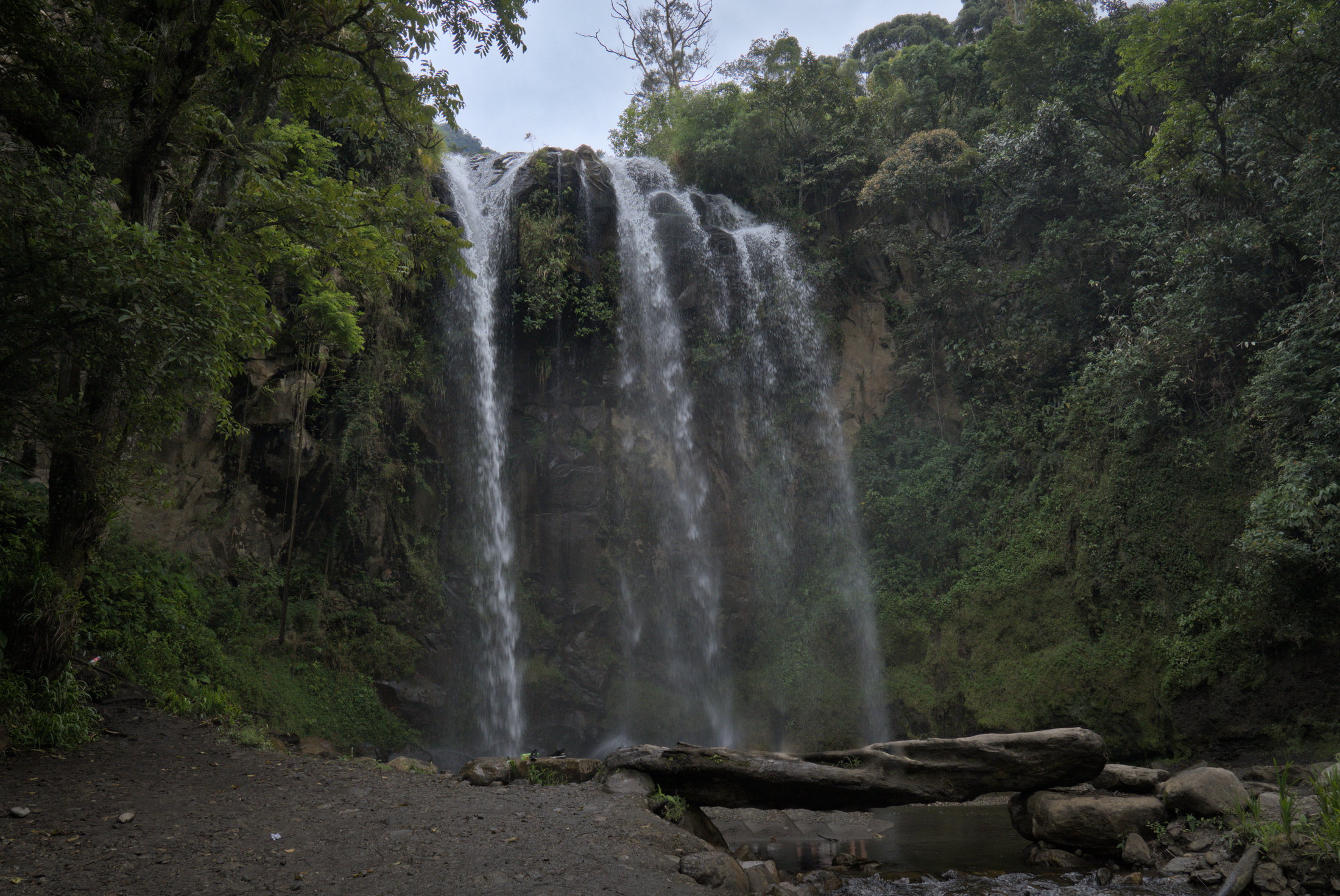
Originally called Cascada de Chin Chin, it is now better known as Manto de la Novia—the “Bride’s Veil”—for the bright white curtain of water that resembles a wedding veil. Here you can ride a tarabita across the canyon or hike the trail down to its base. The path winds through lush greenery and takes you over a hanging bridge above the Pastaza River, one of the most scenic spots on the entire Waterfalls Route and a perfect place for photographs.

Its name comes from the fact that some visitors claim to see the shape of a devil’s face in the rock formations behind the falls. Rising nearly 80 meters in three dramatic drops, it’s one of Ecuador’s most powerful waterfalls. Two access routes offer different experiences: the short path (about 10 minutes) is easier and more direct, while the original one (about 20 minutes) leads through stone tunnels, narrow stairways, and suspension bridges—ending with views so close you can feel the thunder and spray of the water.

Set within the buffer zone of Llanganates National Park, Machay lies in a landscape that is home to rare wildlife such as spectacled bears, tapirs, and even jaguars—though these animals stay far from the road and nearby villages. The waterfall itself is reached by a 15-minute walk, leading to two drops of cold mountain water. On sunny days, visitors often bathe in the natural pool just below the second fall, making it one of the most refreshing stops on the route.
This isn’t just planning—it’s understanding. These are things every traveler should know about Baños before they get here.

Discover why Baños feels unique among Ecuadorian towns, from its nature to its daily rhythm.

Discover how a simple swing became Baños’ most iconic spot, mixing resilience, views, and play.

Rain doesn’t stop the fun—explore waterfalls, hot springs, and cafés perfect for wet afternoons.
Once you’ve explored the route, you’ll want a good place to sleep, eat, and maybe soak. Plan ahead here.
